

How Does the UK Postcode System Work?
The UK’s postcode system is unique and structured for both urban and rural areas. Unlike other formats, a UK postcode narrows down locations to very specific areas or even individual streets, providing essential precision for navigation, deliveries, and business operations. Using our postcode lookup tools and map integration, UK postcodes start with letters indicating the geographic region, followed by numbers that narrow down the area even further.
Using our postcode lookup tools and map integration, UK postcodes start with letters indicating the geographic region, followed by numbers that narrow down the area even further.
Why Choose Woosmap’s UK Postcode Finder?
Our postcode finder tool is designed specifically to help you:
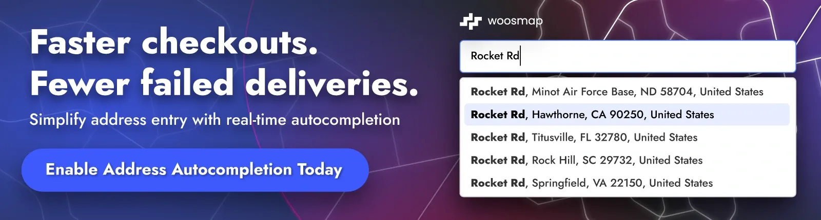
- Enhance Delivery Accuracy: With the correct postcode, delivery errors are minimized using our postcode lookup API, ensuring Royal Mail packages arrive without delays.
- Confirm Locations Across the UK: Instantly verify postcodes and addresses across England, Scotland, Wales, and Northern Ireland with our integrated map and search tools.
- Ensure Data Privacy: Unlike many postcode services, Woosmap’s lookup tools don’t collect personal data, respecting your privacy.
- Using Postcodes for Smooth Deliveries
When it comes to shipping across the UK, an accurate postcode is essential. Delivery servicesrely on our postcode lookup API and mapping tools for efficient route planning and address verification, which helps minimize lost packages and delays. Our postcode finder provides quick access to reliable data, including full address details and map locations, ensuring you have the correct information every time.
The Benefits of Accurate Postcode Verification
From reducing misdelivered packages to ensuring customer satisfaction, verifying postcodes using our search and lookup tools is essential for both personal and business use. Here are some ways our UK postcode finder can benefit you:
- E-commerce and Retail: Accurate postcodes help e-commerce sites confirm customer addresses through our lookup APIs, leading to fewer failed deliveries during checkout and better customer experience.
- Efficient Business Operations: For UK-based companies, accurate postcode data from our search tools means less time lost on manual address verification and more streamlined operations.
- Improved Customer Records: For businesses, verified postcodes enhance data accuracy in CRM systems using our lookup API, enabling better-targeted marketing and streamlined customer support.
How to Find Your UK Postcode Quickly
Using our postcode finder tools and lookup features is simple
- Enter the street address or partial location details in the postcode search form.
- Use our postcode lookup API to get the corresponding UK postcode within seconds.
- Confirm your address for deliveries, customer records, or personal reference through our map display.
Our tool supports a wide range of postcode lookups across England, Scotland, Wales, and Northern Ireland, offering reliable information through our search API and map integration for both urban and rural locations.
Postcode Areas, Districts, and Sectors Explained
Each UK postcode is divided into several segments, which reveal different levels of location detail. Additionally, understanding how these segments help in planning routes using our map tools can greatly benefit delivery services and emergency responders. Enhanced map-based visuals provide even more backdrop to geographical navigation using our postcode lookup API.
- Area: The first letters represent the postcode area (e.g., «SW» for Southwest London).
- District: The following numbers and letters indicate the district, often corresponding to local boroughs or neighborhoods.
- Sector: The final section of letters and numbers pinpoints a more specific area, sometimes down to an individual street code.
Understanding this postcode breakdown helps in managing deliveries, planning optimal routes with our map tools, and even determining emergency service paths, as it allows location identification down to very precise spots using our postcode lookup API.
The Importance of Postcodes in Emergency Services
Postcodes play a crucial role in the UK’s emergency services, aiding ambulance, fire, and police departments in identifying precise locations through our postcode lookup tools. Since 2015, emergency responders have utilized postcode data via our map integration and API to pinpoint locations more accurately, which can make a life-saving difference in critical situations.
Additionally, our postcode finder tool offers support with the inclusion of map locations and address lookup features to assist in providing immediate visual context for emergency situations or service reroutes.
UK Postcodes and Business Efficiency
For companies, having accurate postcode information from our lookup tools and map APIs is invaluable. Postcodes streamline logistics, improve customer satisfaction through precise deliveries, and reduce the cost of returned packages. Postcodes also facilitate accurate data collection and address lookup, which is vital for market analysis, customer segmentation, and optimizing routes for field teams using our mapping tools. Understanding customer patterns through detailed postcode reports aids in tailoring marketing strategies more effectively.
Postal Codes in Rural Areas and Remote Locations
The UK postcode system is particularly beneficial in rural areas where addresses are often sparse. By including postcodes in address lookups and mapping tools, even isolated properties can be pinpointed accurately. This system benefits delivery services, local businesses, and government services by providing exact location data in regions where traditional address formats may be less precise. It’s crucial to remember that in such regions, having proper postcode data can also help improve service delivery, including mail redirection and forwarding — vital services that cater to the unique demands of rural living using our postcode search and mapping tools.